Officially named the Dharmveer Swarajya Rakshak Chhatrapati Sambhaji Maharaj Coastal Road, Mumbai’s Coastal Road Project represents one of the city’s most ambitious infrastructure undertakings — an 8-lane expressway designed to run the entire length of Mumbai’s western sea-facing front. Phase 1, connecting Marine Drive to the Bandra-Worli Sea Link, has already delivered results that sound almost too good to be true: a journey that once took 40-45 minutes now takes just 9-10 minutes, and the entire stretch is completely toll-free.
Here’s the complete, current picture of this genuinely transformative first phase, and where the rest of the project stands.
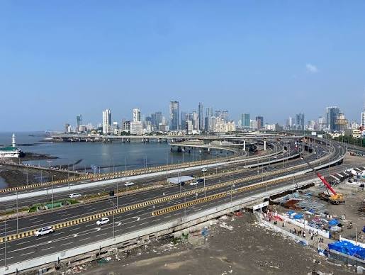
Mumbai Coastal Road Phase 1 Quick Facts
| Detail | Information |
| Official name | Dharmveer Swarajya Rakshak Chhatrapati Sambhaji Maharaj Coastal Road |
| Starting point | Princess Street Flyover, Marine Lines/Marine Drive |
| Ending point | Bandra-Worli Sea Link (Worli end) |
| Phase 1 length | 10.58 km |
| Full project length | 29.2 km (Marine Drive to Kandivali, extending to Bhayandar) |
| Executed by | Brihanmumbai Municipal Corporation (BMC) |
| General consultant | AECOM |
| Toll status | Completely toll-free |
| Fully operational | Mid-2024 through 2025-2026 |
| Speed limit | 80 km/h |
Where Phase 1 Begins and Ends
Mumbai Coastal Road Phase 1 runs from the Princess Street Flyover at Marine Lines to the Worli end of the Bandra-Worli Sea Link, covering South Mumbai’s western coastline.
Key route facts:
- Total Phase 1 length: 10.58 km
- Splits into southbound and northbound arms
- Includes twin tunnels beneath Malabar Hills, with one measuring 1 km at 40 feet diameter — the first under-sea tunnel of this scale built in India
- Includes a 550-metre underpass within the stretch
- Entry and exit points at Marine Drive, Breach Candy, Haji Ali, and Worli interchanges
The Dramatic Travel Time Improvement
This is genuinely the standout achievement of Phase 1, and the before-and-after figures reflect a real transformation for South Mumbai commuters.
Documented time savings:
- Worli-to-Marine Drive journey reduced from 40-45 minutes to just 9-10 minutes
- This represents one of the most dramatic percentage improvements among Mumbai’s major infrastructure projects
- Once the full 29.2-km project (through Kandivali) completes, overall travel time savings could reach up to 1 hour 20 minutes for the complete corridor
Why This Project Was Built
Understanding the specific traffic and pollution problems this coastal road addresses explains the scale of investment and ambition behind it.
Core objectives:
- Dramatically reduce transportation-related traffic and pollution along Mumbai’s western corridor
- Establish a toll-free expressway connecting South and North Mumbai
- Provide a substitute north-south trunk route to improve overall city mobility
- Reduce projected daily usage congestion, with the full project expected to serve approximately 130,000 vehicles daily
- Develop 70 hectares of open space on reclaimed land alongside the road itself
Toll-Free Status: A Genuine Commitment
Unlike many of Mumbai’s other major road projects, the Coastal Road has been consistently positioned and delivered as a toll-free corridor.
Toll policy details:
- The operational Marine Lines-to-Worli stretch carries no user charge whatsoever
- Vehicles continuing onto the Bandra-Worli Sea Link (a separate, connected structure) do pay the applicable FASTag toll for that specific bridge
- This toll-free commitment was specifically announced by then-CM Eknath Shinde ahead of the phase’s completion
- Reflects BMC’s stated goal of making this corridor accessible to the widest possible range of commuters
Vehicle Restrictions and Operating Rules
Given its design as a high-speed coastal corridor, Phase 1 enforces specific rules about which vehicles can use it and how.
Key restrictions:
- Cars and permitted public transport vehicles are allowed
- Two-wheelers and pedestrians are barred entirely
- Heavy vehicles are restricted from entry (with exceptions for BEST and ST buses, and passenger-carrying vehicles)
- Three-wheelers and animal-drawn carts are prohibited
- Round-the-clock, 7-day operation as of full opening (earlier restricted hours during initial rollout have since expanded)
- No stopping permitted anywhere on the mainline
Engineering Highlights Worth Knowing
This project incorporates genuinely notable engineering achievements, particularly given the challenges of building through Mumbai’s dense coastal geography.
Notable engineering features:
- Twin underground tunnels at Malabar Hill and Girgaum Chowpatty
- The Malabar Hill tunnel is India’s first under-sea tunnel of its scale — 40 feet in diameter
- Multiple interchanges spanning 16 km of the full 29.2-km project
- Intelligent Traffic Management Systems (ITMS) incorporating AI-based traffic monitoring and smart signaling
What’s Still Under Construction: Phase 2
Understanding where the rest of this project stands helps set realistic expectations for anyone hoping to eventually use the full coastal corridor.
Phase 2 status:
- Known as the Versova-Bandra-Dahisar Link (VBDL), extending the corridor further north
- Currently under construction, with partial commissioning expected in late 2026 and into 2027
- Full completion of the entire project, including the northern extension to Dahisar and Bhayandar, is projected for 2026-2028
- Until Phase 2 fully opens, travel between Bandra and Dahisar continues to rely on the Western Express Highway and Link Road
Connecting the Dots: A Near-Continuous Corridor Already Exists
Even with Phase 2 incomplete, Mumbai drivers can already combine existing infrastructure to create a substantially connected journey across the city’s western and eastern corridors.
Current connected route possibilities:
- Combining Phase 1, the Bandra-Worli Sea Link, and existing roads allows a near-continuous Dahisar-Bandra-Worli-Marine Drive journey in 2026, with one interchange required at the Bandra end
- The upcoming Sewri-Worli Connector will eventually link the Coastal Road directly with Atal Setu and Eastern Freeway, creating a genuine high-speed route between Mumbai’s western shoreline and eastern suburbs
- South Mumbai areas benefiting most from current Phase 1 access include Worli, Nepean Sea Road, Parel, and Prabhadevi
FAQs
Q1. Is the Mumbai Coastal Road Phase 1 really completely free to use?
Yes — the operational Marine Lines-to-Worli stretch carries no toll charge at all. The only cost applies if you continue onward onto the separate Bandra-Worli Sea Link, which has its own independent FASTag toll.
Q2. Can I ride my scooter or motorcycle on the Coastal Road to save time?
No — two-wheelers are barred entirely from this corridor, along with three-wheelers, animal-drawn carts, and pedestrians. It’s designed exclusively for cars and permitted public transport vehicles.
Q3. When will I be able to drive continuously from Marine Drive all the way to Dahisar or Bhayandar?
Not yet fully — Phase 2 (Versova-Bandra-Dahisar Link) remains under construction, with partial commissioning expected in late 2026-2027 and full project completion projected for 2026-2028. Until then, you’ll need to use existing roads like Western Express Highway for the Bandra-to-Dahisar stretch.
Q4. What happens if I try to stop on the Coastal Road for any reason?
Stopping is not permitted anywhere on the mainline, and the corridor uses ANPR cameras for monitoring, including speed and number-plate violations. If you need to stop, use one of the designated interchanges at Marine Drive, Breach Candy, Haji Ali, or Worli rather than the mainline itself.