Seven states, one continuous road, and a journey that takes you from the Arabian Sea coast in Gujarat to the hills of Assam near Bangladesh’s border. NH 27 is India’s second-longest national highway, and unlike the north-south giant NH 44, this one runs almost entirely east-west — making it the backbone of what planners call the East-West Corridor. If you’ve been searching for the exact route, length, or start-end points of NH 27, here’s a complete, verified breakdown.
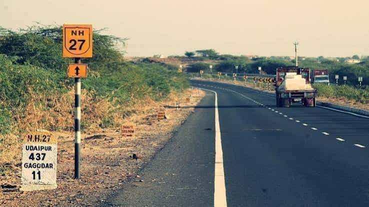
Running roughly 3,507 km from Porbandar in Gujarat to Silchar in Assam, NH 27 quietly does a lot of heavy lifting for India’s freight and passenger movement. It doesn’t get the same attention as NH 44, but for anyone dealing with logistics, real estate near the corridor, or just planning an ambitious road trip, it’s arguably just as important.
NH 27 Quick Facts
| Detail | Information |
| Starting point | Porbandar, Gujarat |
| Ending point | Silchar, Assam |
| Total length | Approximately 3,507 km (some sources list figures between 3,200 km and 3,660 km depending on realignment and measurement method) |
| States covered | 7 — Gujarat, Rajasthan, Madhya Pradesh, Uttar Pradesh, Bihar, West Bengal, Assam |
| Direction | East-West (part of the NS-EW Corridor) |
| Rank | Second-longest national highway in India, after NH 44 |
| Maintained by | Ministry of Road Transport and Highways (MoRTH) / NHAI |
| Highway type | Originally 4-lane; several stretches now upgraded to 6-lane |
| Speed limit | 100 km/h (cars), 80 km/h (buses/medium goods vehicles), 60 km/h (heavy trucks) |
| Major cities linked | Rajkot, Udaipur, Kota, Jhansi, Lucknow, Gorakhpur, Muzaffarpur, Siliguri, Guwahati |
Start and End Points
NH 27 begins at Porbandar, a coastal town in Gujarat known for being Mahatma Gandhi’s birthplace, and terminates at Silchar in Assam’s Barak Valley — a region that depends heavily on road connectivity given its distance from the rest of the state. That’s the full breadth of the highway: from a fishing port on the west coast to a town tucked near India’s northeastern frontier.
Between these two points, the highway doesn’t just connect two cities — it stitches together entirely different economic zones: Gujarat’s industrial belt, Rajasthan’s mineral and tourism economy, the dense agricultural plains of UP and Bihar, and finally the tea and connectivity-starved Northeast.
The Route, State by State
Here’s how NH 27 actually threads across the map:
Starting in Gujarat, it passes through Rajkot, Morvi, Samakhiali, Radhanpur, and Palanpur before crossing into Rajasthan near Abu Road. In Rajasthan, it runs through Udaipur, Chittorgarh, Bundi, and Kota — a stretch that also happens to pass near some of the state’s most visited heritage sites.
From there, the highway enters Madhya Pradesh briefly around Shivpuri before crossing into Uttar Pradesh at Jhansi. Through UP, it connects Kanpur, Lucknow, Ayodhya, and Gorakhpur — a corridor with heavy pilgrim and commercial traffic, especially around Ayodhya.
Entering Bihar, NH 27 passes Gopalganj, Muzaffarpur, and Darbhanga before crossing into West Bengal through Purnia, Dalkola, and Siliguri. The Siliguri stretch is a critical chokepoint — it’s part of the narrow “Chicken’s Neck” corridor that connects mainland India to the entire Northeast region.
Finally, in Assam, the highway runs through Bongaigaon, Guwahati, Nagaon, and Haflong before reaching Silchar. The Haflong-Silchar section, cutting through hilly terrain, is one of the more challenging parts of the entire route.
Why NH 27 Matters More Than Its Length Suggests
The Siliguri corridor is the single most strategically important stretch on this highway. Barely 20-odd kilometres wide at its narrowest point, this is the only land link between mainland India and its northeastern states — meaning NH 27 isn’t just a regional road here, it’s a national security and supply-chain lifeline. Fuel, construction material, and daily essentials for Assam, Meghalaya, Tripura, and beyond move through this stretch.
On the western end, the highway supports very different traffic — agricultural and mineral exports from Gujarat and Rajasthan moving toward inland markets. Kota and Udaipur, both on this route, have grown their logistics and warehousing sectors partly around this east-west access.
Road Conditions and What Travellers Should Know
Lane quality varies a lot more on NH 27 than on some other major highways. The Gujarat and Rajasthan sections are largely modern four-lane or six-lane stretches with decent surfacing. Through Bihar and parts of West Bengal, expect more mixed traffic — tractors, two-wheelers, and pedestrian crossings sharing the carriageway, which slows things down considerably even where the road itself is in good shape.
The Assam stretch, particularly Haflong to Silchar, involves hill terrain with sharper curves and lower practical speeds regardless of the posted limit. Monsoon season can bring landslide risk in this section, similar to what NH 44 faces in Jammu & Kashmir. If you’re planning to cover this stretch, it’s worth checking recent road advisories rather than assuming smooth hill driving year-round.
Toll plazas are spread across the developed sections — roughly three dozen at last count — with rates varying by state and vehicle category rather than a flat toll for the whole corridor.
FAQs
Q1. Why does NH 27’s length vary across different sources?
You’ll see figures anywhere from about 3,200 km to 3,660 km. This comes down to how bypass sections, realigned stretches, and older versus newer measurements are counted. The most consistently cited figure, based on NHAI-linked data, is around 3,507 km — treat that as the reliable reference point.
Q2. Is NH 27 safe for long-distance solo driving?
Most of the Gujarat, Rajasthan, and UP stretches are well-trafficked and safe for daytime driving. The Siliguri corridor and the Assam hill sections deserve extra caution — narrower roads, mixed traffic, and occasional weather disruptions mean it’s worth planning driving hours around daylight rather than pushing through at night.
Q3. Does NH 27 connect to NH 44?
Yes. The two highways intersect near Jhansi, which means a traveller could technically switch from the east-west corridor to the north-south one at that junction — useful if you’re planning a multi-leg trip covering both.
Q4. Which is the most difficult stretch to drive on NH 27?
The Haflong-Silchar section in Assam is generally considered the toughest — hilly terrain, sharper turns, and monsoon-related landslide risk make it slower and more demanding than the flatter stretches further west.