Few highways in India carry the pilgrimage weight of NH 501 — a roughly 90-110 km spur road connecting Khanabal near Anantnag to Panchtarni, one of the final camps on the traditional route to the Amarnath Cave shrine. This isn’t a route most people drive for ordinary transit; it exists primarily to serve the Amarnath Yatra, one of the largest and most physically demanding Hindu pilgrimages in India, and its development has been directly shaped by the needs of that annual journey.
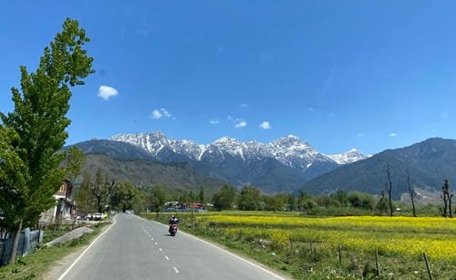
NH 501 Quick Facts
| Detail | Information |
| Starting point | Panchtarni, Anantnag district, Jammu and Kashmir |
| Ending point | Khanabal, Jammu and Kashmir (junction with NH 44) |
| Total length | Approximately 90-110 km |
| Union territory | Entirely within Jammu and Kashmir |
| Type | Spur road of NH 44 |
| Maintained by | National Highways Authority of India (NHAI) |
| Primary function | Access route for Amarnath Yatra pilgrims |
| Panchtarni elevation | 3,505 m (11,499 ft) |
| Major ongoing project | ₹5,300 crore widening project, including a planned tunnel |
Where NH 501 Begins and Ends
NH 501 starts at Panchtarni, a high-altitude locality in Anantnag district that serves as one of the final overnight camps for pilgrims walking to the Amarnath Cave, and runs south through Chandanwari and Pahalgam before reaching Khanabal, where it connects to NH 44. Panchtarni sits at a considerable elevation of over 3,500 metres, reflecting just how far into the Himalayas this highway reaches.
The Route Through the Pilgrimage Corridor
Leaving Panchtarni, NH 501 passes through Chandanwari before reaching Pahalgam, a well-known hill town and the traditional starting point for pilgrims undertaking the Amarnath Yatra on foot. Continuing south, the highway runs through Batakut and Naibasti Hardukichroo before reaching Aishmuquam and Martand, and finally terminating at Khanabal.
Pahalgam itself functions as a major staging point along this route — most pilgrims and tourists travelling toward Amarnath organize their journey around this town, whether continuing on foot from here or using vehicle access as far as road conditions allow.
Understanding the Amarnath Yatra Connection
This highway exists in close relationship with one of India’s most significant annual pilgrimages. The full Amarnath Yatra via the Pahalgam route covers roughly 46 km on foot from Pahalgam to the cave shrine, passing through Chandanwari, Sheshnag, and Panchtarni before the final approach. NH 501 provides vehicle access along a meaningful portion of this route, considerably reducing the walking distance pilgrims must cover compared to earlier decades when road infrastructure was far more limited.
The pilgrimage itself typically runs for roughly five to six weeks each summer, with 2025’s yatra scheduled from early July through early August — meaning this highway experiences dramatically different traffic patterns during yatra season compared to the rest of the year.
The ₹5,300 Crore Widening Project
This is genuinely significant current infrastructure news worth understanding. In April 2023, the Union Road Transport Minister announced a major widening project covering the 110-km stretch from Khanabal to Panchtarni via Chandanwadi and Baltal, with an estimated cost of around ₹5,300 crore. The project specifically aims to drastically reduce pilgrim travel time to the Amarnath shrine from Srinagar.
As part of this development, plans include a 5-km concrete footpath from Panchtarni to the Amarnath shrine itself, complete with security barricades on both sides for pilgrim safety. Perhaps most significantly, the project includes a proposed 10-km tunnel between Sheshnag and Panchtarni, specifically designed to help pilgrims avoid the risk of snowfall-related disruptions during their journey — a genuine safety improvement given how weather-dependent this high-altitude route has historically been.
Additionally, a separate greenfield section — the Chandanwari-Sangam Highway, including an 11-km Khanabal-Baltal Tunnel (also called the Sheshnag Tunnel) beneath Ganesh Top — is planned to connect the South Route (via Pahalgam) with the North Route (via Baltal), potentially transforming how pilgrims can move between the two traditional Amarnath approach paths.
Two Routes to Amarnath: How NH 501 Fits In
It’s worth understanding that NH 501 serves specifically the southern, Pahalgam-based route to Amarnath. A separate northern route exists via Baltal, near Sonamarg, which is considerably shorter at just 14-16 km but involves steeper, more strenuous terrain. Pilgrims choose between these routes based on physical capability and preference — the Pahalgam route via NH 501 is longer but more gradual, while Baltal offers a quicker but tougher ascent.
Road Conditions and Seasonal Considerations
Given this highway’s high-altitude terrain and its direct connection to a seasonal pilgrimage, road conditions and accessibility shift considerably by time of year. During yatra season, expect heavy pilgrim and support-vehicle traffic, along with security measures given the scale of the annual gathering. Outside this window, particularly in winter, snow can significantly affect accessibility on the higher stretches near Panchtarni and Chandanwari.
Speed Limits and Practical Notes
Given the mountainous terrain and the highway’s primary function serving pilgrim traffic rather than through-transit, there’s no consistent high-speed stretch to reference here. Safe travel depends heavily on current conditions, yatra-season traffic management, and the specific segment of road you’re on — this is fundamentally a careful, weather- and event-dependent journey rather than a standard highway drive.
Challan and Safety Compliance
Standard Motor Vehicles Act frameworks technically apply within Jammu and Kashmir, but during yatra season specifically, compliance with pilgrimage traffic management, security checkpoints, and designated vehicle movement windows matters considerably more than routine speed enforcement. Given the safety concerns around snowfall risk that the tunnel project specifically aims to address, following official advisories on weather-related closures is a genuine safety necessity rather than a minor precaution.
FAQs
Q1. When is the best time to travel NH 501 if I’m planning the Amarnath Yatra?
The yatra typically runs for five to six weeks each summer, generally from early July through mid-August, though exact dates vary yearly and require advance registration. Outside this window, the route may face weather-related restrictions, particularly near the higher-altitude Panchtarni stretch.
Q2. How much has the widening project changed travel time to Amarnath so far?
The ₹5,300 crore project, including the planned Sheshnag-Panchtarni tunnel, is designed to significantly reduce both travel time and weather-related risk once complete. As with large infrastructure projects in high-altitude terrain, check current construction status before your specific travel dates rather than assuming the full upgrade is finished.
Q3. Should I choose the Pahalgam route (NH 501) or the Baltal route for Amarnath?
The Pahalgam route via NH 501 is longer at roughly 46 km but more gradual, making it more suitable for pilgrims prioritizing manageable terrain over speed. The Baltal route is shorter at 14-16 km but considerably steeper. Your choice should depend on physical fitness and available time.
Q4. Is NH 501 accessible outside the Amarnath Yatra season?
The lower stretches through Pahalgam remain generally accessible for regular tourism given Pahalgam’s popularity as a hill station. The higher sections toward Panchtarni and Chandanwari are more seasonally restricted and see far less traffic and infrastructure activity outside the yatra window.