Running to within sight of the Line of Control, NH 701 covers roughly 126 km connecting Baramulla to Tangdhar in Kashmir’s Kupwara district — a highway that carries both genuine strategic weight and a currently active construction story worth understanding before travelling it. Maintained by the Border Roads Organisation rather than NHAI, this route reflects the security-sensitive nature of the terrain it passes through.
NH 701 Quick Facts
| Detail | Information |
| Starting point | Baramulla, Jammu and Kashmir (junction with NH 1) |
| Ending point | Tangdhar, Kupwara district |
| Total length | Approximately 126 km |
| Union territory | Entirely within Jammu and Kashmir |
| Type | Spur road of NH 1 |
| Maintained by | Border Roads Organisation (BRO) |
| Major towns linked | Rafiabad, Handwara, Kupwara, Trehgam, Chowkibal |
| Border connection | Extends toward Teetwal via connecting road, close to Line of Control |
| Current status | Under active phased upgrade to two-lane with paved shoulders |
Where NH 701 Begins and Ends
NH 701 starts at Baramulla, at its junction with NH 1, and runs northwest through Kashmir’s Rafiabad and Kupwara districts before terminating at Tangdhar, close to the Line of Control with Pakistan. This positions the highway in one of the more security-significant corridors in the Kashmir Valley, given its proximity to the border and its role connecting relatively remote frontier areas to the rest of the valley’s road network.
The Route Through Rafiabad and Kupwara
Leaving Baramulla, NH 701 passes through the Rafiabad area before reaching Handwara, a significant town in Kupwara district. From Handwara, the highway continues through Kupwara town itself, then Trehgam, before reaching Chowkibal and finally Tangdhar.
Beyond Tangdhar, a connecting road known as the Gundishat Bridge-Teetwal Road extends the practical reach of this corridor further toward Teetwal, a border village sitting directly on the Line of Control along the Kishanganga River. Teetwal holds particular historical significance as the site of the Tithwal Bridge, one of only five official crossing points along the LoC, originally built in 1931, destroyed during the First Kashmir War, and jointly reconstructed by India and Pakistan in 1988.
Current Construction Status: What’s Actually Happening Right Now
This is genuinely important, current information rather than a general caveat. As of the most recent government updates, NH 701 remains under active phased construction, broken into distinct project packages. The Baramulla-Handwara section, designated Package 1, is currently under upgradation to two-lane standard with paved shoulders, and had achieved roughly 25.4% physical progress as of the latest reporting.
The Handwara-Kupwara, Kupwara-Trehgam, and Trehgam-Chowkibal sections form Package 2 and have been included in the Annual Plan for 2025-26, meaning active work on these stretches is expected to ramp up going forward. The final Chowkibal-Tangdhar section remains part of the highway’s broader development plan without a specific completion timeline confirmed in recent updates.
Given this genuinely mid-construction status, anyone planning to travel this route should expect a mix of upgraded and still-developing sections, and should check current status through BRO or Jammu and Kashmir administration channels before departure rather than assuming a uniformly finished highway.
The Bandipora-Lolab Connectivity Gap
Worth understanding as useful regional context: there is currently no direct National Highway connecting Bandipora and Lolab, two areas in this general region. Instead, these areas rely on a combination of state roads and the section of NH 701 linking Handwara with Kupwara, followed by a state road to reach Lolab. Proposals for upgrading this connectivity are assessed periodically by the government based on traffic density and broader infrastructure planning frameworks, but no direct national highway link currently exists for this specific route.
Similarly, for travellers considering the Sangrama-Sopore-Handwara-Chowkibal corridor as an alternative, the existing connectivity relies on a state road between Sangrama and Handwara, connecting into NH 701 between Handwara and Chowkibal — meaning this isn’t a single continuous national highway option either.
Strategic and Historical Significance
Given its proximity to the Line of Control and its connection toward Teetwal, NH 701 carries genuine strategic importance beyond ordinary civilian connectivity, which is part of why it falls under Border Roads Organisation maintenance rather than standard NHAI administration — a pattern consistent with several other highways in this series that run close to sensitive frontier areas.
The broader Tangdhar-Teetwal region has also historically been significant for cross-LoC family reunions and limited trade initiatives during periods of relative calm between India and Pakistan, adding a layered human and political significance to this corridor beyond its role as a transport route.
Road Conditions: What to Actually Expect
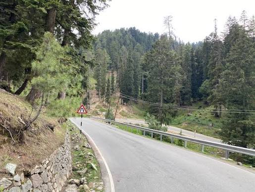
Given the highway’s active, phased construction status, expect genuinely variable road conditions depending on which specific stretch you’re travelling. The Baramulla-Handwara section, being furthest along in its upgrade at roughly a quarter complete, may still show meaningful construction-related conditions rather than a finished two-lane paved-shoulder road. Sections further along toward Tangdhar, not yet reaching active construction phases as of the latest updates, likely remain in their pre-upgrade state.
Speed Limits and Practical Driving Notes
Given both the mountainous, security-sensitive terrain and the highway’s genuinely mixed construction status, there’s no consistent high-speed stretch to reference for this route. Safe travel here depends considerably more on current road and security conditions than on any posted numeric limit — this is a corridor where checking current status before departure matters more than usual.
Challan and Practical Compliance Notes
Standard Motor Vehicles Act frameworks apply within Jammu and Kashmir, but given this highway’s border proximity and security context, practical travel considerations extend beyond routine traffic compliance to include awareness of security checkpoints and any active restrictions specific to the Kupwara-Tangdhar frontier area. These can shift based on regional security conditions, so checking current advisories is a genuinely necessary step rather than an optional precaution.
FAQs
Q1. Is NH 701 currently fully paved and two-lane throughout, or should I expect construction?
Expect construction-affected conditions on multiple stretches. The Baramulla-Handwara section is under active upgrade with partial progress, while the Handwara-to-Chowkibal sections are planned for work in the 2025-26 annual plan. The final Chowkibal-Tangdhar stretch’s timeline remains less defined in recent updates.
Q2. Can I travel from NH 701 directly to Teetwal on the Line of Control?
Yes, via the connecting Gundishat Bridge-Teetwal Road beyond Tangdhar, though given this area’s direct border proximity, security conditions and any applicable access restrictions should be confirmed before travel rather than assumed to be open by default.
Q3. Is there a direct national highway connecting Bandipora and Lolab?
No — currently, travel between these areas relies on a combination of state roads and the Handwara-Kupwara section of NH 701, followed by further state road travel to Lolab. There’s no single, direct national highway link for this specific route as of the latest available information.
Q4. Why is NH 701 maintained by BRO rather than NHAI like most other highways in this series?
Given its location close to the Line of Control and its strategic significance in this frontier region, NH 701 falls under Border Roads Organisation maintenance, consistent with how India manages several other highways in security-sensitive border areas rather than through standard NHAI administration.