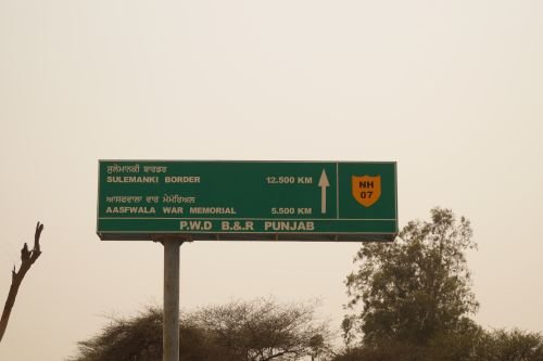
One end sits at the India-Pakistan border in Punjab’s cotton belt; the other reaches toward one of the highest motorable points near the India-China frontier, close to the source of the Saraswati river. NH 7 covers roughly 845 km across four states, passing through Sikh pilgrimage towns, Punjab’s agricultural heartland, and finally the Char Dham circuit in Uttarakhand before reaching Mana — the last Indian village before the Tibet border.
Before diving into the route, one clarification worth making upfront: NH 7 as a civilian, publicly driveable highway reaches Mana village, just past Badrinath. Mana Pass itself — the actual high-altitude pass at over 5,600 metres near the Line of Actual Control — is a separate, military-built BRO road beyond the village, generally restricted and not open for ordinary tourist travel. Here’s the complete, accurate picture of this route.
Quick Facts About NH 7 Highway (Fazilka to Mana Pass)
| Detail | Information |
| Starting point | Fazilka, Punjab (near India-Pakistan border) |
| Civilian end point | Mana village, Uttarakhand (last Indian village before the border) |
| Total length | Approximately 845 km |
| States covered | 4 — Punjab, Haryana, Himachal Pradesh, Uttarakhand |
| Formed from | Merger of old NH 10, 15, 22, 58, 64, 71, 72, and 73 |
| Maintained by | National Highways Authority of India (NHAI); border stretch under BRO |
| Major pilgrimage towns | Rishikesh, Devaprayag, Rudraprayag, Karnaprayag, Badrinath |
| Speed limit | 100 km/h (cars) on plains; significantly lower through hill and mountain sections |
| Major cities linked | Bathinda, Patiala, Dehradun, Rishikesh |
Where NH 7 Begins and Where It Actually Ends
NH 7 starts at Fazilka, a Punjab town close to the India-Pakistan international border, known for its cotton and agricultural trade. From there, it runs east and eventually north for over 800 km, finally reaching Mana — a small village in Uttarakhand’s Chamoli district, widely regarded as the last inhabited Indian village before the Tibetan plateau.
The pass itself, Mana Pass, sits roughly 47 km further north of the village at an elevation exceeding 5,600 metres — one of the highest motorable points anywhere, built originally by the Border Roads Organisation for military purposes. This section lies within a sensitive border zone near the Line of Actual Control and inside the Nanda Devi Biosphere Reserve, meaning it isn’t a standard tourist extension of the highway the way the rest of NH 7 is. If your interest is specifically in visiting Mana Pass rather than Mana village, current permit and access requirements need to be checked directly, since restrictions here can change based on border conditions.
The Route Through Four States
Leaving Fazilka, NH 7 runs through Abohar and Malout before reaching Bathinda, one of Punjab’s larger commercial centres. It continues through Barnala, Sangrur, Patiala, and Rajpura — a stretch through some of Punjab’s most agriculturally productive districts.
Entering the Chandigarh-Haryana belt, the highway passes through Panchkula and Raipur Rani before crossing into Himachal Pradesh briefly around Paonta Sahib, a significant Sikh pilgrimage town associated with Guru Gobind Singh. From here, NH 7 crosses into Uttarakhand, reaching Dehradun, the state capital.
From Dehradun, the highway follows the classic Char Dham pilgrimage route through Rishikesh, Devaprayag, Rudraprayag, Karnaprayag, and Chamoli before reaching Badrinath — one of the four sacred Char Dham sites — and finally Mana village just beyond it.
The Char Dham Stretch: Why This Section Sees the Heaviest Traffic
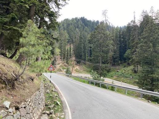
The Rishikesh-to-Badrinath portion of NH 7 is, by a wide margin, the most heavily travelled section of this entire highway. It forms a core part of the Char Dham pilgrimage circuit, and during the yatra season — roughly April through November, weather permitting — this stretch sees enormous volumes of pilgrim traffic, buses, and private vehicles navigating narrow mountain roads alongside the Alaknanda river.
This section is also the most weather-vulnerable part of NH 7. Landslides are common during monsoon months, particularly between Rudraprayag and Badrinath, and the road has historically faced closures during heavy rainfall. Anyone planning this stretch, pilgrim or otherwise, should build flexibility into travel plans rather than assuming a fixed schedule will hold regardless of conditions.
Speed Limits Across the Route
The Punjab and Haryana plains sections follow standard national highway limits — up to 100 km/h for cars on open stretches. Once NH 7 enters Himachal Pradesh and then Uttarakhand’s hill terrain, actual safe speeds drop considerably regardless of what’s technically posted. The Rishikesh-to-Badrinath stretch in particular involves narrow, winding roads along river valleys where overtaking is often restricted and caution matters far more than adherence to a numeric limit.
Local traffic police frequently manage flow on the pilgrimage stretch during peak season, including timed convoy systems on the more constrained sections — following their directions takes precedence over general highway rules here.
Challan Rules on NH 7
Standard Motor Vehicles Act fine structures apply across Punjab, Haryana, Himachal Pradesh, and Uttarakhand, with overspeeding penalties generally in the ₹1,000-₹4,000 range depending on vehicle category. Each state notifies its own specific rates within this framework, so amounts can differ slightly as you move from Punjab’s plains into Uttarakhand’s hills.
Given the volume of pilgrim traffic on the Char Dham stretch specifically, enforcement here often focuses as much on traffic management and convoy compliance as on straightforward speed violations — ignoring local traffic police instructions during peak yatra season can result in penalties beyond a standard speeding challan.
FAQs
Q1. Can I drive all the way to Mana Pass, or only to Mana village?
Ordinary tourist and civilian travel on NH 7 reaches Mana village, the last inhabited settlement before the border. Mana Pass itself, well beyond the village, is a restricted military-built road near the Line of Actual Control, and access typically requires specific permissions that can vary based on current border conditions — don’t assume it’s open for a casual visit.
Q2. When is the best time to drive the Rishikesh-to-Badrinath stretch?
The Char Dham yatra season, roughly May through October, sees the road open and maintained but also extremely crowded with pilgrim traffic. If avoiding congestion matters more than pilgrimage timing, the shoulder months just after the season opens in May or just before it closes in October tend to be less crowded, though weather risk remains a factor either way.
Q3. Is NH 7 prone to landslides, and how should I plan around that?
Yes, particularly the Rudraprayag-to-Badrinath section during monsoon months (roughly July to September). Build extra time into any journey through this stretch during monsoon season, and check current road status through Uttarakhand’s disaster management or state PWD advisories before departure rather than assuming the road is clear.
Q4. Does NH 7 connect with the other major highways heading into Uttarakhand, like NH 34?
Yes — NH 7 intersects with several regional highways along its Uttarakhand stretch, making it possible to combine routes for a broader Himalayan circuit. If you’re planning a longer trip covering multiple pilgrimage or hill destinations in the state, checking junction points near Dehradun and Rishikesh can help plan a more efficient multi-highway route.